How a Florida hurricane led to historic floods in North Carolina’s mountain towns
How a Florida hurricane caused historic flooding in North Carolina's mountains
FOX 35 meteorologist Brooks Garner explains how hurricane Helene’s landfall in Florida led to catastrophic flooding in North Carolina’s Appalachian Mountains. He breaks down the massive transport of water vapor from the tropics, the role of the upslope effect in the Blue Ridge Mountains, and why this storm was so destructive in areas far from the coast.
Hurricane Helene may have struck Florida, but its effects traveled much farther than expected. Towns in North Carolina’s Appalachian Mountains, like Asheville, Hendersonville, and Old Fort, faced catastrophic flooding from the storm’s remnants. The event has been described as a once-in-1,000-year flood.
But how did a Florida hurricane cause such widespread destruction in North Carolina? According to Brooks Garner, senior meteorologist at FOX 35, it was due to the massive transfer of water vapor from the tropics to the mountains. "A huge amount of water vapor was transported from the heart of the tropics, right to the Blue Ridge Mountains, forced uphill and essentially its nature wringing out a giant wet sponge."
This intense transport of moisture, combined with the mountainous terrain of North Carolina, set the stage for the devastating floods.
What is the upslope effect?
The upslope effect, also known as orographic lifting, occurs when moist air is forced to rise over mountains, cooling and condensing into rain as it climbs. During hurricane Helene, this effect made the storm significantly more intense as it collided with the Blue Ridge Mountains.
Garner described the impact as the "worst-case scenario," explaining, "There was a southerly wind that hit those mountains almost perpendicularly, and it was really the worst-case scenario with some of the worst intensities of water vapor observed in the modern area globally happening right here in the Blue Ridge Mountains."
This upslope effect funneled vast amounts of rain directly into the valleys, making flooding in towns like Hendersonville and Old Fort especially severe.
Why North Carolina’s mountain towns were hit so hard
Towns in North Carolina’s Appalachian region, including Asheville, Hendersonville, and Old Fort, are particularly vulnerable to flooding because they are located in valleys. When intense rainfall occurs, these valleys act as natural channels for water, directing large volumes into the towns.
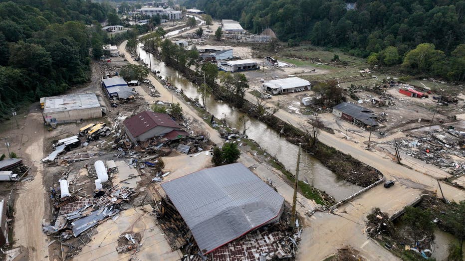
In just a few days, more than 20 inches of rain fell in some areas, overwhelming the local landscape and causing flash floods that washed away homes, roads, and other infrastructure. The mountainous terrain funneled this water downhill, leading to devastating conditions for the towns below.

An aerial view of flood damage wrought by Hurricane Helene along the Swannanoa River on October 3, 2024 in Asheville, North Carolina. (Photo by Mario Tama/Getty Images)
When was the last flood like this?
The last time North Carolina’s mountain region saw flooding on this scale was in 1916. Brooks Garner referenced this historical event: "The last time this happened was in 1916. It was a really bad flood event for that region. But at the time, there were considerably fewer people."
In 1916, the floodwaters destroyed infrastructure and cut off towns from the rest of the country. Today, over a century later, Hurricane Helene brought similar destruction, but with more widespread impact due to the population growth in the region.
How climate change intensified the flooding
Climate change played a major role in making hurricane Helene wetter than storms of the past. A warmer atmosphere holds more moisture, which leads to heavier rainfall during storms.
Garner explained, "In a warmer climate, the atmosphere can support more water vapor. So if an event 100 years ago would have a severe impact, today, in theory, that impact would be even more severe because there’s more water vapor to work with."
This increased moisture made hurricane Helene more powerful, and when the storm reached North Carolina’s mountains, the additional water vapor led to catastrophic flooding.
How to prepare for extreme weather events like this
As extreme weather events become more frequent, communities in regions like the Appalachian Mountains need to better prepare for potential disasters. Brooks Garner offered some key steps for how these communities can ready themselves for future storms:
Garner emphasized the importance of awareness and education in preparation. "The answer is teaching the history. There have been extreme events with flooding in Colorado. . . passing this unbelievable flood. . . education of both the population and officials" is essential to help communities understand the risks they face and how to respond to them.
Garner also pointed out that a sense of normalcy bias—the belief that something catastrophic won’t happen because it hasn’t before—can leave communities underprepared. He emphasized the need to take warnings seriously, even if the forecast seems hard to imagine. As extreme weather becomes more frequent due to climate change, "how do you deal with not having electricity for several weeks? How do you deal with having those roads physically cut off from the outside world if you need medication?"
The source:
This article is based on an interview with Brooks Garner, senior meteorologist at FOX 35 Orlando with additional context sourced from previous FOX reporting. This story was reported from Los Angeles.

