

Sedona flooding triggers evacuations and closes multiple Arizona highways
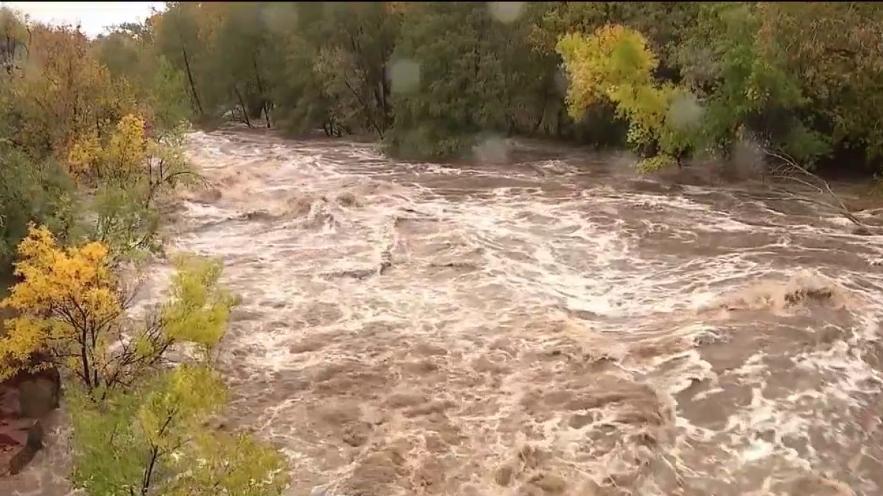
Oak Creek flooding triggers evacuations and rescues in Sedona
Sedona ordered evacuations and closed State Route 89 after Oak Creek overflowed, prompting water rescues and the opening of an emergency shelter. FOX 10's Jacob Luthi has the latest.
SEDONA, Ariz. - The city of Sedona is urging residents to evacuate due to significant rainfall causing flooding on Sunday.
Evacuations:
As of the morning of Nov. 1, Sedona has issued evacuations for zones 8, 9, and 10, and are set in "GO" status due to the elevated waters in Oak Creek. These include Trails End Rd., Trails End Ln., Purtymun Ln., Lomacasi Ln., Art Barn Rd., Art Barn Ln., Arroyo Roble Dr., Amara Ln., Little Ln., L’Auberge Ln., Blackhawk Ln., Newcastle Ln., Oak Creek Mobilodge., Copper Cliffs Dr., Copper Cliffs Ln., Sycamore Rd., the Villas at Poco Diablo Resort, Center for the New Age, Rancho Sedona RV park, houses north of the Rancho Sedona RV park on Bear Wallow Ln., and any other properties adjacent to Oak Creek.
"The state of Go means that the danger in your area is imminent and life is in danger, and you must evacuate," officials wrote.
In a post shared on the city's Facebook, officials added: "Do not cross when there is running water on the road! Oak creek is rising fast - risk of sudden flooding! Please pay attention and stay away from the beds and drain cleansing. Do not cross when there is running water on the road!"
Sedona's evacuation map can be used to prepare for evacuation planning.
Shelters:
A shelter for those who were evacuated has been set up at the Camp Verde Community Gym, located at 473 S. Main Street.
The Sedona Humanitarian Society is also available to help with the pets of those who evacuated, including food and supplies. If you need help, contact them at 928-282-4679.
Tourists React:
People in the area reported receiving emergency alerts around 8 a.m. A couple visiting from Maine recounted that a road they had driven the night before was completely underwater by the time they woke up.
"250 yards from where we were staying, the water was there, and it rose by the time we first saw it to the time we went back and packed up the car, it had risen about 10 feet up the road. It was coming up the road as we left," said tourists Matt and Lisa Johnson. "We thought we'd come to Sedona to check out the sunshine and do some hiking and all of that, but we didn’t expect this."
Residents React:
"We got on the street, and we looked down and were like, oh, the river is coming to us," said Sedona resident Susan Balensky.
Longtime locals also noted the unusual severity of the rising water.
"The park is just one big puddle, and I've never seen it that full," Balensky said. "Like I said, I've seen the river get pretty high and roar and stuff, but not really come up over the banks to the point that it's hitting the houses. So this was a rarity, that’s for sure."
Dig deeper:
Floodwaters came right up to the doorsteps of some homes. Near Sedona's trout farm, a 1975 Cadillac was left half-submerged.
"The work that keeps coming up is unprecedented," Coconino County Emergency Manager Tim Carter said.
Carter said reports first centered on flooded roadways Sunday, before water began threatening homes and businesses. He said local agencies are coordinating their response to address damage and help those impacted.
"The county and all of our public safety partners, we practice for this, we train for this, we have plans for this," Carter said.
Highway Closures:
The flooding has forced several highways in Arizona to close, including:
- State Route 89A between Sedona and Kachina Village (mileposts 375-397)
- State Route 260 near Pinetop-Lakeside (milepost 350)
- State Route 73 between Indian Pine and White River (mileposts 357-351)
- State Route 238 between Maricopa and Gila Bend
All lanes of Interstate 17 have reopened in both directions, as of Sunday afternoon.
Crews with the Arizona Department of Transportation are responding to rockfall incidents across the northern part of the state, using plow trucks to clear the roadways.
The National Weather Service issued a Flood Watch for central and northern parts of the state as rainfall is expected through the evening.
School Closures:
Sedona Red Rock Jr/Sr High School announced the closures of West Sedona School and Sedona-Red Rock Middle/High School for Monday, Nov. 2, citing safety factors for students and staff.
"Some of our teachers and families are currently impacted by flooded homes. Areas of campuses that have been damaged are currently being assessed for staff and student safety," the announcement said in part.
Rescue Operations:
Sedona Fire crews called in extra personnel for "an excessive amount of rescue operations" on Nov. 1, due to rising, rushing waters.
Big picture view:
Coconino County activated their Emergency Operations Center due to the widespread flooding, providing support for residents, businesses, property, and infrastructure within the county, as the region remains under a flood watch through 8:30 p.m. on Sunday.
A call center was activated for information about evacuations, sandbags and road closures at 928-679-8525. More information on evacuation zones and flood preparedness can be found on coconino.az.gov/ready. Additional weather updates can be found here.
Sandbags are available at Pinewood Fire Department, located at 475 E. Pinewood Blvd. and Highlands Fire Department, at 3350 Old Munds Hwy. Self-fill sandbags are available in Thorpe Park, at the parking lot at the north end of N. Aztec St. between Frances Short Pond and the softball fields. Residents are asked to provide their own shovels.
What Drivers Can Do:
"Motorists are advised to expect delays and avoid traveling in these areas. Motorists that choose to travel should never drive into flooded roads or washes. Hazards can be submerged in water and a few inches of running water can sweep away a car," ADOT officials said.
If you are in immediate danger, move to higher ground and call 911.
What's next:
As of Sunday afternoon, there is no estimated time for the highways to reopen.
The Source: Information in this report was gathered from officials with the city of Sedona; the Sedona Humanitarian Society; tourists Matt and Lisa Johnson; Susan Balensky, a Sedona resident; Tim Carter, emergency manager with Coconino County; officials with the Arizona Department of Transportation; the National Weather Service; officials with Sedona Red Rock Jr/Sr High School; the Sedona Fire District; and Coconino County.