The Central American Gyre: What to know as hurricane season continues

Tracking Hurricane Francine in Louisiana
LiveNOW's Christina Evans checks in with FOX's Caroline Shively for the latest weather update on Hurricane Francine in Baton Rouge, LA.
LOS ANGELES - As hurricane season progresses, meteorologists are keeping an eye on the Central American Gyre (CAG), a large-scale weather pattern that often leads to the development of tropical storms and hurricanes. This phenomenon typically forms during the rainy months of May through November and can have far-reaching impacts, especially in the Gulf of Mexico and the Caribbean.
Currently, the National Hurricane Center is monitoring a system within this gyre that could develop into a tropical storm, although chances remain low at 20%. Nevertheless, the CAG has the potential to produce dangerous weather systems, and it’s something to watch closely as we head deeper into the hurricane season.
What is the Central American Gyre?
The Central American Gyre is a broad area of low pressure that forms in the atmosphere during certain times of the year, particularly in late spring and early fall. Unlike the tight, organized structure of a hurricane, the gyre is diffuse and can cover a wide region, extending its impact across hundreds of miles. While the CAG itself may not develop into a storm, it often serves as the breeding ground for tropical disturbances.
The gyre can produce extreme weather, especially in Central America, where its proximity often results in torrential rain, flooding, and mudslides. Occasionally, smaller areas of low pressure break off from the gyre, and under the right conditions—such as warm sea surface temperatures and favorable winds—these areas can intensify into tropical storms or hurricanes.
How does the Central American Gyre impact hurricane season?
While the Central American Gyre may not directly cause hurricanes, it often creates conditions that are ripe for tropical storm development. Historically, several significant storms have originated from the gyre, including Hurricane Michael in 2018, which developed into a devastating Category 5 hurricane after spending time in the gyre.
Tropical storms formed by the gyre tend to emerge in the Caribbean Sea, the Gulf of Mexico, or the eastern Pacific. Though the storms that develop from this pattern are sometimes weaker when they reach U.S. shores, they can still bring dangerous conditions, such as heavy rain, strong winds, and flooding.
Currently, meteorologists are watching a low-pressure system forming in the western Gulf of Mexico. While the chances of this system developing into a tropical storm are low, its proximity to the U.S. means it requires close monitoring.
Why is predicting tropical storms from the Central American Gyre so difficult?
Forecasting tropical storm development from the Central American Gyre is notoriously challenging due to the gyre's size and structure. The system’s broad and disorganized nature means that it can be hard to predict exactly when and where tropical disturbances will form. Models like the Global Forecast System (GFS) often forecast storms that never materialize, as moisture from the gyre sometimes fails to break away and organize into a defined storm.

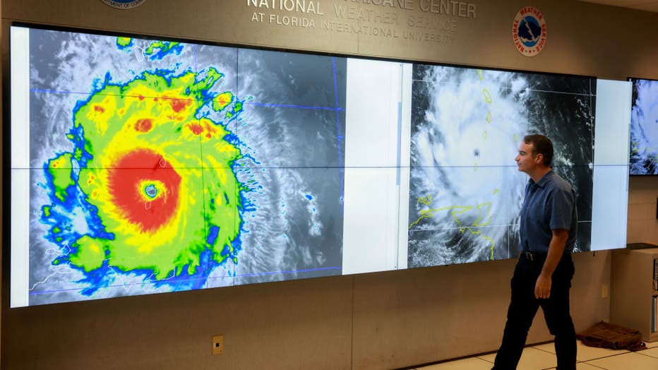
John Cangialosi, Senior Hurricane Specialist at the National Hurricane Center, inspects a satellite image of Hurricane Beryl, the first hurricane of the 2024 season, at the National Hurricane Center on July 01, 2024 in Miami, Florida. ((Photo by Joe Raedle/Getty Images))
Despite these challenges, meteorologists know that early and late in the hurricane season—when the gyre is most active—there's always a risk that a tropical disturbance will emerge. This is why monitoring systems in the Caribbean and the Gulf is critical during these months, as the potential for tropical cyclone formation remains, even when the forecast models struggle to pinpoint exact developments.
What is the outlook for the rest of hurricane season?
As we move further into the hurricane season, conditions in the Atlantic, Caribbean, and Gulf of Mexico become more conducive to tropical storm development. While the Atlantic has experienced limited tropical activity this year, systems in the Caribbean and Gulf, like those that form from the Central American Gyre, can still pose significant threats.
Long-range forecasts suggest that additional tropical activity may develop in the Caribbean in the coming weeks, although no specific systems are currently on the horizon. The key takeaway is that the hurricane season is far from over, and the Central American Gyre will continue to be a feature to watch as the season progresses.
The Source:
This article draws information from the National Hurricane Center, meteorological studies on the Central American Gyre, and previous storm data, including historical references to notable hurricanes and tropical storms that have formed from the gyre. Additional insight comes from research published in the Bulletin of the American Meteorological Society.

