Arizona Monsoon 2023: What to expect this summer
Arizona Monsoon 2023: What to expect this summer
In a FOX 10 special report, you'll learn all about the elements that make up the monsoon from the wind, the rain, the lightning and the dust, plus a look at what this monsoon season might bring, and some tips on how to make sure your pool and your car are ready for the severe weather.
PHOENIX - The monsoon: Mother Nature's raw power is on full display with walls of dust and wicked winds, to sheets of rain and the deluge of water left behind. Always expect the unexpected because this is Arizona's monsoon.
In a FOX 10 special report, you'll learn all about the elements that make up the monsoon from the wind, the rain, the lightning and the dust, plus a look at what this monsoon season might bring, and some tips on how to make sure your pool and your car are ready for the severe weather.
What exactly is the monsoon?
By definition, the monsoon is not one storm, but instead, a change of winds. And that change creates a weather pattern drawing summer thunderstorms into the southwest.
The monsoon season begins June 15 and lasts through September 30. Here in Arizona, we usually get cooking closer to early July, but it all depends on when the pattern sets up.
During summer, our scorching heat is actually the kick-starter for our monsoon pattern.
During winter, winds move from cool land to warmer ocean waters, but as the land in Mexico and the southwest warms, the wind pattern swaps, and those winds grab low level moisture from the Baja of California and eastern Pacific, pushing it into our direction. At the same time, a ridge of high pressure known as the subtropical high begins to move northward from Mexico.
As it moves closer to the southern Rockies, upper level moisture is drawn into the southwest, too, this time from the Gulf of Mexico. When these two ingredients come together, we have our monsoon – and we know what that means: rain and storms.
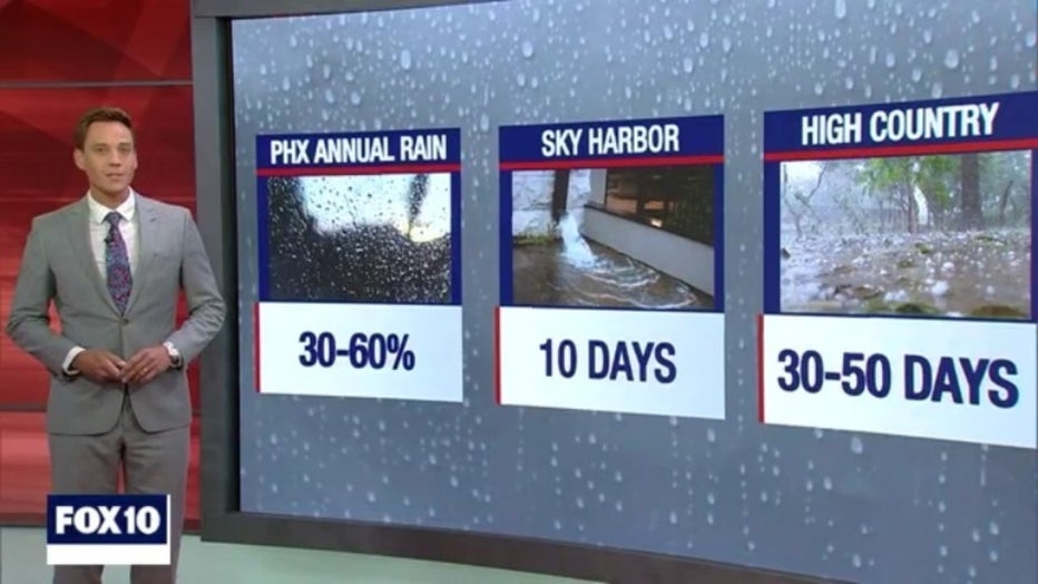
In fact, Phoenix sees between 30 and 60% of their annual rain during the monsoon. Sky Harbor Airport average around 10 days of rain each season. Flagstaff and the high country, where elevation helps trigger storms, averages between 30 and 50 days.
It's most common for storms to develop in the afternoon and early evening, when our temperatures are hottest. But storms can strike at any time, and can turn dangerous quickly. And hand in hand with the monsoon, is our wildfire season.
Wildfire burn scars
"I've got two young kids, and so I was just telling my neighbor I'm nervous about the waters washing down the way 'cause he just said it was coming down a little bit ago, and it sounded like a freight train coming down the road," said Cindy Wilson.
Just one year ago, two wildfires and devastating burn scar flooding.
"We heard a roar and came outside, and the water, a wall of water literally came down this side of the property," said Cindy.
But last year wasn't the first time Flagstaff faced this battle. Nearly 13 years ago, the Schultz Fire torched the mountains, bringing flooding to Cindy's community.
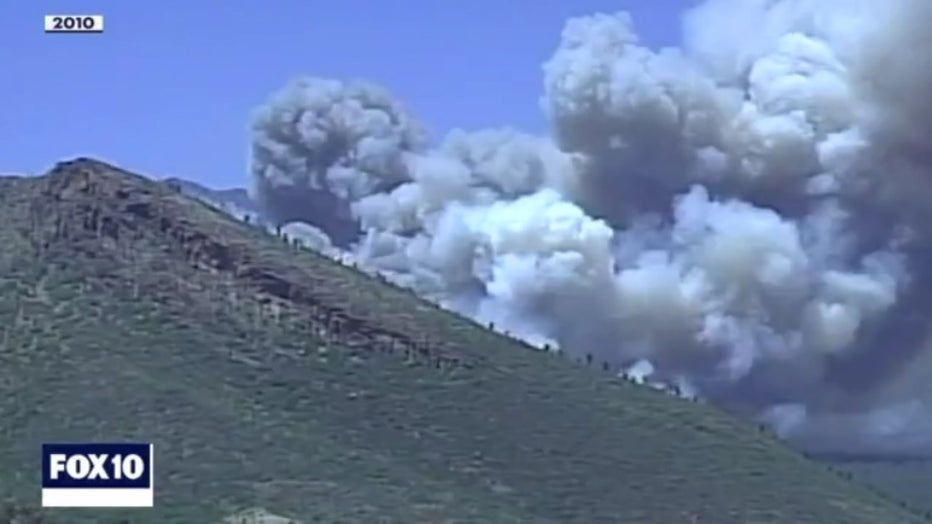
Schultz Fire in 2010 (file)
"Railroad ties, people's swimming pools, people's patio furniture. It was.. it was unconscionable.. it was hard to imagine," she said.
Floodwaters soaked into her home and caked her yard in mud.
"We tried to stop the water. We ran a row of bags straight. And it didn’t work."
After several attempts, they finally found success.
The sandbags helped minimize flooding but couldn't stop the problem entirely. That's where Coconino County came in, taking extensive flood mitigation efforts. But after a decade, and two new fires, the county is stepping back in to revitalize and expand those measures.

(Cindy Wilson's sandbags (file))
"This spring, Coconino County Flood Control District has $30 million worth of projects that are going into construction right now," said Coconino County Deputy County Manager and Flood Control Administrator, Lucinda Andreani.
Their mitigation goals include expanding existing channels, so they can direct larger flows of water. They're also lining the channels with a special type of concrete after debris tore up the old channel walls just last year.
While work done in the channels is important in keeping the neighborhoods safe from the water flow, what might be even more important is the work that’s done uphill in the forest. Measures taken here help to mitigate the debris and the sediment. And trenches being built to hold more water and guide it the right direction.
Many of these trenches are being expanded and reinforced.
"The rocks will line this trench, so that it doesn't erode away as the volume of water increases and the velocity increases," said Andreani.
While the county is updating post-Schultz mitigation in some areas, other parts of Flagstaff need first-time mitigation from the ground up.
"We will not be able to mitigate through all corridors, all the flood corridors. We’re focused on two right now, and on forest work in several other watersheds. But we won’t be able to complete all that work this year," said Andreani.
They hope to complete work in Wupaki Trails, Timberline, Fernwood, and Doney Park this year. Tackling Copeland, Peaceful Way, and a larger project in Government Tank next spring. Their goal is for communities to handle up to 2 inches of rain in 45 minutes: considered a 25-year flood.
"There will be a certain amount of threat to this area based on the rainfall event for many many many years, at least a decade. That said, the mountain will begin to heal," said Andreani.
She believes their measures will advance that healing: keeping more homes safe, sooner. Homes like Chase Wilson's.
"It just so happens that my area right here is just in the middle of a flood path."
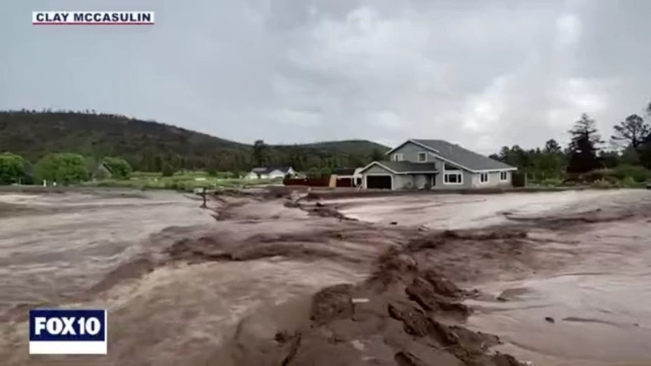
The Wilson home in 2022 (file) (Clay McCasulin)
Last year, Chase's home was destroyed when debris-filled floodwaters overtook his property.
"You can see right there, the house used to be right there."
Now, they're rebuilding, adding higher concrete walls to the exterior of the home, on top of an existing concrete barrier wall provided by the county.
"While it was really hard to deal with at the time, it was also a nice place to refresh. It brought a lot of appreciation for what I have, and a different mind set on how I want to take care of my property."
Chase says his family, including three small children, hope to move back home by August, dependent upon the monsoon season. In his neighborhood, county efforts will include channel expansion, uphill forest work, and adding a large underground storm drain that will direct water into the upgraded channel.
"This will, I believe, quadruple the amount of water the channel can handle now."
Still, Chase knows the threat won't entirely disappear. And like many in Flagstaff, he's taking a hopeful approach to the future.
"Being afraid doesn’t do a whole lot for me. What I can really put my energy into is doing as much as I can, being as prepared as possible, making sure my community and neighborhood are taken care of as best we can."
It's the same approach that helped Cindy through her flood more than a decade ago.
"It's just part of it. I made a choice not to stress about it."
As a reminder, anyone in a burn scar flood zone should prepare for potential flooding now. Prepare by packing and setting up sandbags. You can get more information on sandbag filling stations at https://coconino.az.gov/2936/Sandbag-Information.
If you already have sandbags from last year, maintain that mitigation. Replace only broken or worn bags, as the rest should still be functioning.
Also, get flood insurance as soon as possible. It may take time to set up the insurance and even longer for it to kick in. See https://coconino.az.gov/2934/Flood-Insurance-Information.
Finally, residents around burn scars should sign up for emergency alerts with Coconino County: https://coconino.az.gov/2612/Emergency-Notification-System.
Flooding safety
- 6 inches of moving water can knock a person off their feet
- 12 inches of moving water can lift a vehicle
- 18 to 24 inches of moving water can lift an SUV
- During a flood warning, seek higher ground
Monsoon facts
- Monsoon in Arizona: June 15 to September 30
- Wettest monsoon in Phoenix: In 1984, 9.56 inches of rain fell at Sky Harbor
- Driest monsoon: In 1924, 0.35 inches of rain fell at Sky Harbor
What can we expect this summer?
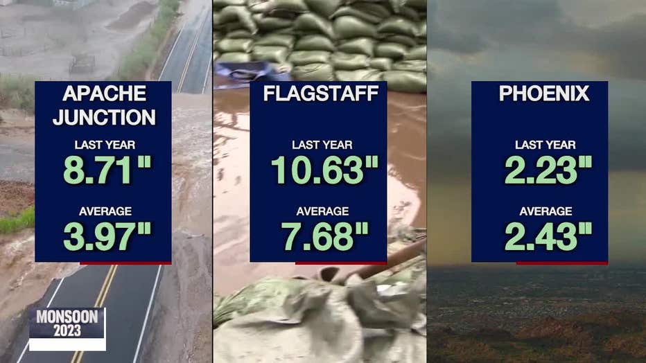
We all know the monsoon doesn't impact everyone equally. Just last year, Apache Junction saw nearly 9 inches of rain, way above their average of 4 inches. Flagstaff saw about 10.5 inches, 3 inches above normal. At Sky Harbor Airport, near-average rainfall, at 2.25 inches, but north Phoenix saw almost double that.
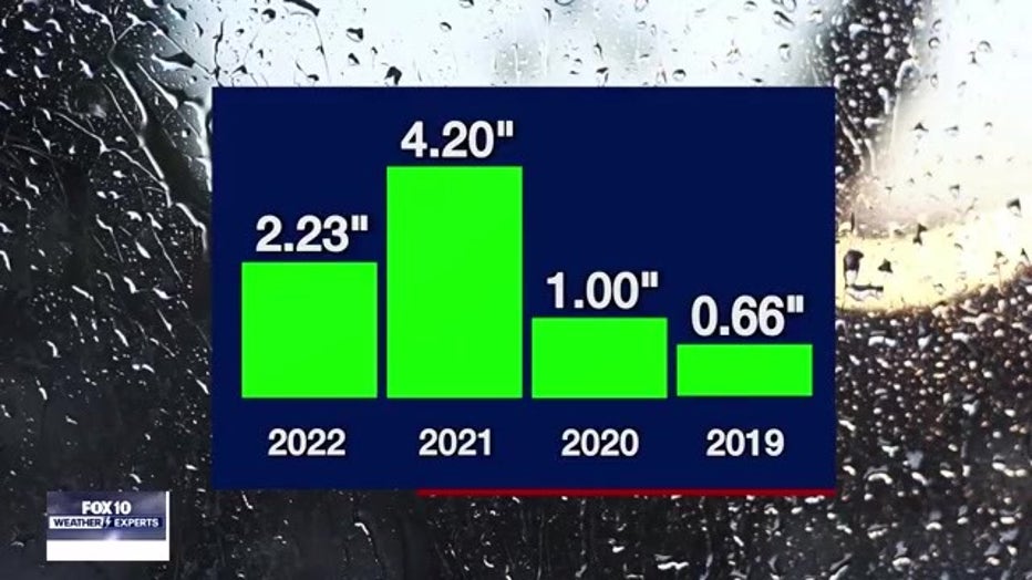
From year to year, we see even more variability. Last year, and in 2021, we picked up plenty of rain statewide, But 2019 and 2020 were some of the driest years on record across the southwest. Not so fondly known as the "non-soon."
So how is this year looking?
First off, forecasting the monsoon is complex, with tons of moving parts, meaning we can't make any guarantees. But there are some factors that may help or hurt our bottom line.
Let's start with our wet winter. Trends suggest wet winters are more often followed by dry monsoons. It's possible this is because the snowpack across the west slows the heating process in May and June. As we learned earlier, high heat helps create our monsoon pattern, so our wet winter might hurt our rain chances.
Next up: the El Niño. It was officially pronounced on June 8 and is expected to continue to strengthen this summer and fall.
This pattern is defined by above average sea surface temperatures along the equatorial Pacific. Remember, the difference between cooler ocean waters and warm land helps bring us monsoon moisture, so warmer waters may slow this process and shorten our monsoon window.
But it's not all bad news with the El Niño, which tends to create more tropical activity in the eastern Pacific.
In fact, the National Hurricane Center is calling for above average tropical activity this season.
There's no guarantee for direct impacts to Arizona, but it does bring a higher likelihood of rainy days if we can tap into some of those tropical systems.

As for the Climate Prediction Center, a branch of the National Weather Service, their forecast leans slightly toward below average rain totals.
Combining the climate signals mentioned, with the CPC's forecast, we're expecting a delayed start to the official monsoon pattern, meaning below average rainfall in June and possibly July. By August and September, we're forecasting a better chance for average rainfall.
If we hit above average totals, it may be due to only one or two heavy storms, which can spell trouble. Remember: monsoon rains aren't uniform and while one part of the state could miss out, another may hit it big.
Either way, the FOX 10 Weather Experts will be with you whenever and wherever the storms develop this season.
Severe thunderstorm watch vs. warning
Watch
- Conditions are favorable for a severe storm to develop.
- Be prepared to go indoors.
Warning
- A severe storm is passing or will pass soon.
- Damaging winds or large hail is likely.
- Take cover indoors immediately.
Prepping trees for the Arizona monsoon
Straight and narrow is the aim for any golfer, but the drive through McCormick Ranch Golf Club in 2021 was anything but.
"Quite a mess to clean up."
The course, bearing the brunt of a powerful microburst. More than 200 trees were uprooted by 90-mile-per-hour winds.
"Trees down in the middle of the parkway. In fact, I couldn't even get in through the streets. I ended up having to go around the back," said course superintendent Eric Chase.
Since then, Chase says they've learned a lot about tree maintenance, especially when it comes to watering.
"I think a lot of times we are over-watering trees out here too frequently. Trees would do much better under deep and infrequent water situation."
Chase says pruning and trimming large branches from your trees is also important.
"You don't want dense canopy on your tree because that increases wind resistance, and they're more susceptible to blowing over."
And you want to keep your tree health by feeding it what it needs.
"Iron is pretty critical out here. Our soil is often times deficient in iron. Nitrogen is also pretty critical. Calcium, potassium, gypsum, is a great product to use. I'd say a balanced fertilizer that you can buy at your local nursery."
But if there was one good thing to come out of that 2021 storm? The course got a little greener.
"Every time you lose a tree, your grass gets a little better, and our turf has definitely improved."
Now that your trees are ready for the monsoon what about your car and pool?
Historic haboob
- Phoenix, July 5, 2001
- Measuring a mile high
- 100 miles wide
Driving in a dust storm safety
- Pull off the road or highway if possible
- Turn off vehicle headlights
- Set emergency brake and take foot off brake
- Stay in vehicle with seatbelt buckled
- Wait for storm to pass
- If you can't pull over, leave lights on and drive slowly. Use road lines as a guide

