Flood Watch
until MON 5:00 AM MST, Eastern Cochise County below 5000 ft including Douglas/Wilcox, Upper Gila River and Aravaipa Valleys including Clifton/Safford, Southeast Pinal County including Kearny/Mammoth/Oracle, Western Pima County including Ajo/Organ Pipe Cactus National Monument, Dragoon/Mule/Huachuca and Santa Rita Mountains including Bisbee/Canelo Hills/Madera Canyon, Tucson Metro Area including Tucson/Green Valley/Marana/Vail, Tohono O'odham Nation including Sells, Baboquivari Mountains including Kitt Peak, Upper San Pedro River Valley including Sierra Vista/Benson, Chiricahua Mountains including Chiricahua National Monument, Galiuro and Pinaleno Mountains including Mount Graham, Santa Catalina and Rincon Mountains including Mount Lemmon/Summerhaven, White Mountains of Graham and Greenlee Counties including Hannagan Meadow, South Central Pinal County including Eloy/Picacho Peak State Park, Upper Santa Cruz River and Altar Valleys including Nogales, Northwest Plateau, Lake Havasu and Fort Mohave, North Phoenix/Glendale, Aguila Valley, Mazatzal Mountains, Tonopah Desert, Gila Bend, San Carlos, East Valley, Northwest Pinal County, Northwest Valley, Southeast Valley/Queen Creek, Globe/Miami, Deer Valley, Fountain Hills/East Mesa, Apache Junction/Gold Canyon, Buckeye/Avondale, Tonto Basin, Rio Verde/Salt River, South Mountain/Ahwatukee, Dripping Springs, Southeast Gila County, Pinal/Superstition Mountains, Scottsdale/Paradise Valley, New River Mesa, Sonoran Desert Natl Monument, West Pinal County, Superior, Cave Creek/New River, Central Phoenix, Yavapai County Mountains, Little Colorado River Valley in Navajo County, Western Mogollon Rim, Coconino Plateau, Chinle Valley, Yavapai County Valleys and Basins, Oak Creek and Sycamore Canyons, Grand Canyon Country, Chuska Mountains and Defiance Plateau, Northeast Plateaus and Mesas South of Hwy 264, Little Colorado River Valley in Coconino County, Black Mesa Area, Marble and Glen Canyons, Northeast Plateaus and Mesas Hwy 264 Northward, Northern Gila County, White Mountains, Kaibab Plateau, Eastern Mogollon Rim, Little Colorado River Valley in Apache County

What to know about Baltimore's Francis Scott Key Bridge

Published March 26, 2024 6:52 AM MST

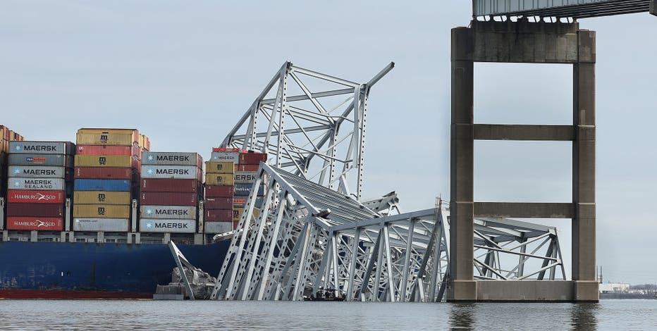
The Francis Scott Key Bridge in Baltimore, Maryland collapsed after it was struck by a large container ship early Tuesday morning. Here's what we know about the bridge and its history.

What does the Francis Scott Key Bridge connect?

Baltimore's Francis Scott Key Bridge stretches 1.6 miles and crosses over the Patapsco River in Maryland. The bridge opened in 1977 as the final link in I-695 Baltimore Beltway and spans the Patapsco River at the entrance to a busy harbor. 

The river leads to the Port of Baltimore, a major hub for shipping on the East Coast that also provides convenient and safe transportation for local and interstate traffic.

Image 1 of 12
▼

Francis Scott Key Bridge, courtesy MDTA

Francis Scott Key Bridge history:

The bridge is named for the author of the Star Spangled Banner, Francis Scott Key, where he was inspired to write the words of the Star Spangled Banner.

Initial bids for construction of the proposed tunnel were opened on July 30, 1970, but the price of the proposals were much higher than the engineering estimates. Officials drafted alternative plans, including the concept of a four-lane bridge.

Featured
Baltimore Key Bridge collapse live updates: 2 rescued, several others believed in water

A portion of Baltimore's Francis Scott Key Bridge collapsed after it was struck by a large container ship early Tuesday morning, sending several vehicles and people into the frigid water below.

Construction of the bridge began in 1972 and opened to traffic on March 23, 1977. The project cost an estimated $110 million. The bridge project is 10.9 miles in length.

Map: Where is the Francis Scott Key Bridge in Maryland? 

Image 1 of 2
▼

Where is the Francis Scott Key Bridge?

ExplainersMarylandNews