

Steamboat Fire: Evacuations lifted for two Gila County communities
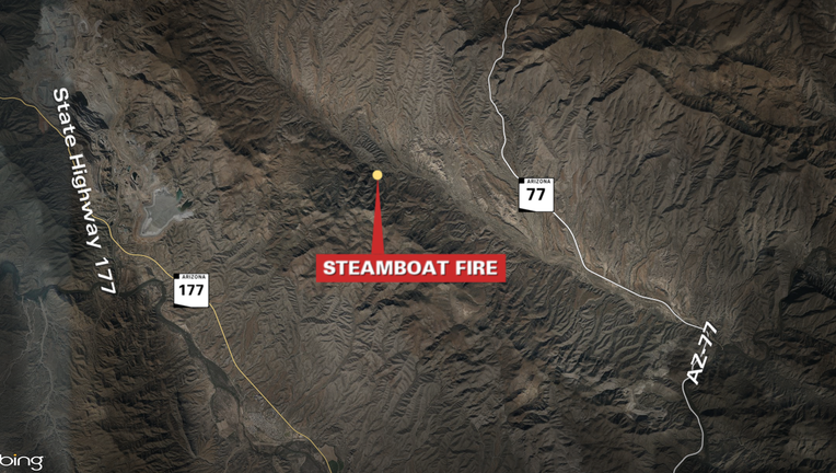
The Steamboat Fire broke out near the old mining town of Troy in Arizona on June 26, 2026.
GILA COUNTY, Ariz. - Two Gila County communities who were told to evacuate due to the Steamboat Fire can now return to their homes.
What we know:
Linx Ranch and Victory Ranch communities were told to leave their homes by the Gila County Sheriff's Office and the county's Office of Emergency Management due to "imminent" and "life-threatening" danger on June 26. By July 1, the order was lifted.
Thursday, July 2 update
11:06 a.m.
The Steamboat Fire is now fully contained. It burned 1,576 acres.
Wednesday, July 1 update
1:22 p.m.
Containment of the Steamboat Fire is at 90%. The fire has burned 1,576 acres. All evacuation orders related to the fire have been lifted.
Monday, June 29 update
5:03 p.m.
"The Steamboat Fire situated northeast of Kearny, Ariz., saw minimal activity in the fire area. Infrared mapping from a fixed-wing aircraft measured the fire at 1,576 acres, with containment now at 90%.
Today, Steamboat operations used infrared-equipped aviation support to give firefighters accurate heat detection data, helping them pinpoint and eliminate areas of residual heat threatening containment. Crews also begin repairing areas affected by firefighting activities which included repairing hand-built fire lines, roads, and trails, as well as restoring natural features that were disturbed. These efforts help prevent soil erosion and keep the fire contained.
Resources on scene will continue to mop-up residual heat and continue with suppression repair activities through tomorrow. The Southwest Zone Type 3 Incident Management team is preparing to turn the fire back over to local fire managers. This will be the last update on the fire unless there is significant change or increase in activity," the Bureau of Land Management said.
11:37 a.m.
The Steamboat Fire remains at 14% containment with an estimated 1,683 acres burned. "SET" alerts remain in place for the Wind Spirit Community along Dripping Springs Road. The "GO" status remains in effect for Linx and Victory Cross Ranch.
"Today, firefighting personnel will continue suppression operations, focusing on strengthening and maintaining established containment lines. Fire managers will coordinate with Gila County Emergency Managers to assess the status of active alerts, after considering prevailing conditions during periods of increased fire activity, typically occurring through the hottest part of the day," Bureau of Land Management Arizona officials said.
Sunday, June 28 update
6:27 p.m.
"The Steamboat Fire, situated northeast of Kearny, Ariz., is estimated at 1,683 acres and is 14% contained. Fire suppression efforts over the last three days have steadily increased containment. Firefighters are operating under challenging conditions, including steep rocky terrain and elevated temperatures. Throughout the day they maintained coordination with aviation resources to advance their direct attack objectives. Airtankers deployed fire retardant, and helicopters transported water from Kearny Lake to reinforce suppression operations on the ground.
Dry, gusty winds drove the fire's spread, fueled by desert grass and brush. Although winds are forecast to ease, critical hot and dry conditions are expected to persist. Gila County Emergency Management and the Gila County Sheriff's Office have lifted the ‘Set’ status in the Ready, Set, Go model for Dripping Springs. This area will return to ‘Ready’ status. The ‘Set’ status remains in effect for the Wind Spirit Community along Dripping Springs Road, while the ‘Go’ status continues for Linx and Victory Cross Ranch. Drivers on Highways 77 and 177 might see the fire, both roads are still open to traffic," the Bureau of Land Management said.
10 a.m.
"Today, the plan is to maintain emphasis on protecting structures, use direct suppression tactics when feasible, strengthen containment features including two-track roads and hold areas where containment lines have been constructed. Firefighters will continue to coordinate with aviation resources to advance efforts toward containing and controlling the fire. The fire is anticipated to remain active throughout the daytime heat. Although wind conditions are forecasted to moderate, critical Red Flag weather conditions are projected to persist," authorities said.
What we don't know:
The cause of the fire is unknown.
What you can do:
The Gila County Public Health & Community Services Facebook page is posting updates on the fire – click here to view the posts.
Map of the area where the fire is burning