

'Strong' El Niño: Could this be the start of a wet winter in Arizona?
PHOENIX - Winter officially starts in less than a month, and we’ve got snow in the forecast this week.
With an El Niño pattern, could this be the start of a wet winter? We’re officially under what is described as a "strong" El Niño.
It’s forecast to last through at least this spring, but, in Arizona, an El Niño isn’t a guarantee for a wetter-than-average season.
After digging through the numbers, and chatting with the National Weather Service in Flagstaff, we got a better idea of our odds.
So, let’s start with the basics.
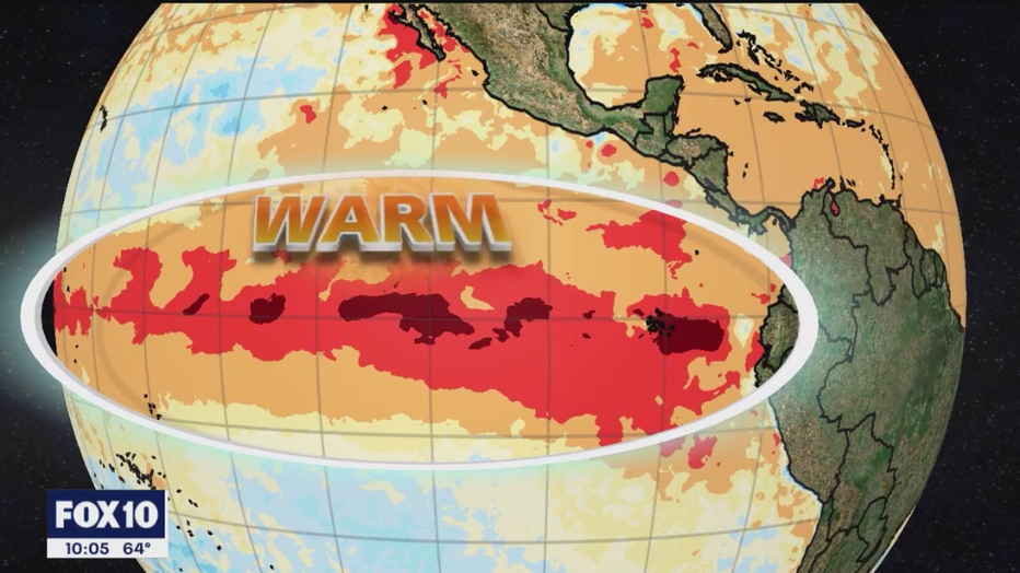
During an El Niño, waters along the equatorial Pacific Ocean turn hotter than average.
On a map, you'll see a bright red area. That's hot water. That hot water helps brew thunderstorms.
Some of which will head inland. As a result, this is the typical winter pattern that sets up during an El Niño year.
"You can think of the jet stream as being, kind of like this highway that weather systems travel along. So when we’re in an El Niño period, and the southern jet stream gets strengthened, we tend to have more weather systems that will impact the southern half of the United States," explained Robert Rickey, a meteorologist with NWS Flagstaff.
Tend is the keyword.
"Specifically for northern Arizona, when we’re in El Nino cycles, odds tend to favor near to above normal precipitation. There’s a lot of variability there and being in an El Niño period definitely does not guarantee that we’re going to get a lot of rain," Rickey said.
The best way to describe it? Let’s talk baseball.
If you have a batter who’s known for big hits, it’s natural to feel excited and hopeful when he’s up to bat.
But, you also know, he could still strike out.
Take last year, for example.
"We had near-historic snowfall amounts across northern Arizona, we had over 160" of snow just here in Flagstaff alone, and that was during a La Nina period, which on average tends to lead to less precipitation," Rickey said.
Let’s look at some of the numbers to explain that pesky word: "tends."
We’re talking probability, or, the odds.
Since 1950, across Arizona, there have been 25 El Niño events. Of those 25, 17 experienced near-average to above-average precipitation.
Between December and February, that’s about 68% of the time.
Specifically in Flagstaff, the NWS says they’ve experienced above average snow totals for half the El Niño winters on record with just 18% running below average.
Good odds, but not a home run.
Now that we know there are no absolutes in baseball, or El Niño, what about this winter?
Odds are leaning slightly toward above-normal rain or snow in Arizona.
For Phoenix, there's a 35% probability of above-average rain. This year, the global weather pattern seems to be throwing a wrench in the "typical" plan.
"Each El Niño is kind of like a snowflake. They’re all going to be different in some way. One difference between this El Niño and some of the past strong El Niños is that we’re seeing very warm sea surface temperatures over a very broad area," Rickey said.
In fact, much of the Pacific is running hotter than normal.
Some meteorologists are questioning if this could dull some of the more common impacts of El Niño.
Without previous years to compare, only time will tell.
When looking at the last four El Niño winters, we found it was 50/50 for above or below-average rain in Phoenix. Our best season was 2009-2010.
In Flagstaff, three of the four years were near or above-average for snow.
Hopefully, this year plays out the same